From Denali it is a relatively short 150 +/- mile trip to Fairbanks. Much different and smaller than Anchorage, Fairbanks is the "other" major city in AK. The Univ. of AK is there and it has a great small town/college feel. And most importantly it is the gateway to the Arctic Circle. We visited the Musuem of the North on the campus at the university. Although somewhat small this musuem was perhaps the best we have visited so far. The main exhibit combnies AK history, culture and art as represented throughout the stages of AK development.
Museum of the North
Our main objective here was to journey to the Arctic Circle (AC). I had this strange goal of wanting to ride my bike there. So on a beautiful Sunday morning we headed north for the Dalton Hwy. The AC is 200 miles from Fairbanks and although not a difficult drive most of the trip is on gravel/dirt roads and you need to be aware of yield the ROW to oncoming truck traffic. The Dalton was originally called the "haul" road as it's main purpose was to haul supplies to Deadhore and Prudhoe Bay for the AK oil drilling. The road was built along with the AK pipeline, the two following each other north. There is one main stop to the AC (and others beyond) at the Yukon River crossing where food, gas and lodging are available. Also at this stop is a BLM visitor's center describing the area you are travelling through.
Heading north
Yukon River Camp
"Gas Station"
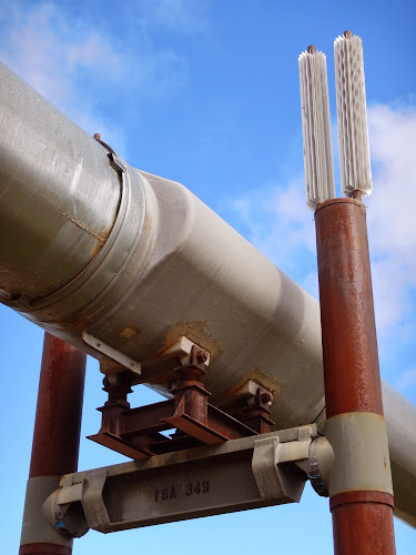
One interesting aspect of this road is the Alaska pipleine. In a few places you can get direct access and see how it was constructed. The line is both above gground (where the soil is unstable) and buried (where there is a base of rock) and above ground the line zig-zags. This design allows for small sections only to be damaged, in an earthquke for example, instead of larger sections if the line was straight. Also shock absorbers are designed into the upright supports to minimize earthquake dangers.
Section of the AK pipeling
Closeup of support
We made it to the AC easily and fortunately the wind was strong so the mosquitos were at bay. Except for the sign there is really no designation where you are. Since this is a high point for many tourists the BLM posts volunteers here and will even give you a certificate upon successfull crossing! Tour busses come this way as well and bring a special carpet with dotted line to "mark the spot". Now I can say I have ridden my bike across the AC.
The "official" line?
Traffic along the highway is relatively light but it is still used as a "haul" road so care must be taken. Although not very visible in this photo, the main truck is being "pushed" by a push truck to help with the inclines.
We did a short hike to "Finger" rock just south ot the AC. It is said this rock points directly to Fairbanks so travellers will be able to find their way south. The hike out is on tundra, a soft spong like terrain.
Finger Rock
It was a long day, 400 miles RT but well worth the effort
After leaving Fairbanks we made a short visit to Chena Hot Springs for a nice hot soak. This is more of a resort but has a CG, restaurant and other visitor facilities. This was a good break.
Chena Hot Spings
Having a nice soak!
Our stop in Faibanks ended our trip north and we officially headed south from here.
More to come....


No comments:
Post a Comment